Traditionally, adding median and splitter islands in Civil Site Design has been a manual and often onerous process. The procedure involves creating these islands as either Profile or Draped Strings, then adding them to a Model Builder model. A significant challenge arises when these islands overlap with road centrelines or edge strings, requiring the user to meticulously trim out these design strings. This task becomes particularly arduous when dealing with multiple islands, turning it into a slow and tedious process.
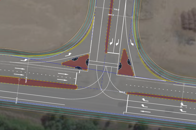
Figure 1: Plan view of an intersection, illustrating the placement of median islands.
Enter Project Assist
Project Assist offers an automated approach to significantly streamline the process of integrating islands into road models. Utilising the power of AI and machine learning, Project Assist intelligently predicts how alignments in a project might be utilised, setting up an optimised workflow and executing tasks with precision.
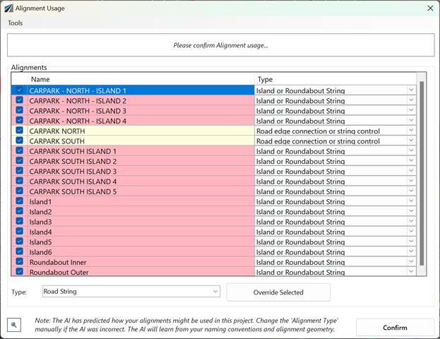
Figure 2: Screenshot of Project Assist displaying an alignment list and the AI’s predictions for categorising these alignments.
Automating Island Creation with Project Assist
Project Assist enhances the process of adding islands, making it more efficient and streamlined compared to traditional methods. The tool automatically detects island alignments within the project, converts them into strings, and seamlessly integrates them into the Model Builder model. Its most remarkable feature, however, is its ability to automatically trim out the edge and crown strings of roads wherever they intersect with the islands, ensuring a clean, accurate design without manual intervention.
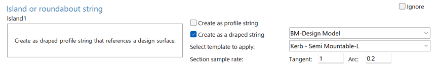
Figure 3: A portion of the Project Assist workflow, depicting a panel where users can select a template for an island and specify the type of string to be created, either as a profile or draped string.
The Benefits of Automation
Project Assist’s automation significantly enhances the creation of median and splitter islands, offering numerous advantages. Its most noticeable benefit is the considerable reduction in time and effort, freeing designers from extensive manual work. The provided example illustrates how the software adeptly trims centreline and edge strings intersecting with islands, a task typically done manually. These modifications are added into Model Builder, marked with “PA” to indicate their origin from Project Assist. Additionally, these automated edits are user-editable, allowing for customisation. Essentially, Project Assist executes tasks in the same manner a user would, but with greater efficiency.
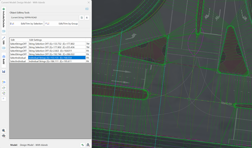
Figure 4: Screenshot of Model Builder showing the area typically used for manual edits, with visible modifications made by Project Assist, notably the strings that have been automatically removed through the islands.
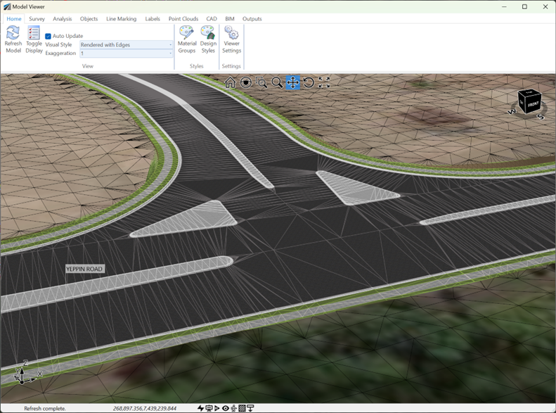
Figure 5: Screenshot from Model Viewer displaying the 3D rendered visualisation of the model
Island Deletion
It might be required to delete an island or recreate the island if there are significant changes to the geometry. Project Assist has its own object deletion command that will not only delete the string, but remove all references of the String. So, any references to the string as edits in Model Builder will be removed and if the String was a Draped String, then it will be removed from the Draped Strings list. When using the Project Assist object deletion command, it is important to tick on ‘Remove Alignment/String References.”
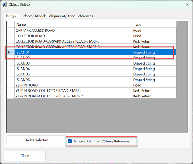
Figure 6: Screenshot of the Project Assist Object Delete form, illustrating the interface for this comprehensive deletion process.
Conclusion:
Project Assist enhances Civil Site Design by offering automated string trimming, which not only saves significant time but also ensures a higher level of precision and accuracy in design. This feature streamlines the process of integrating islands into road models, allowing civil designers to achieve more with less manual intervention.

In the Civil Site Design v26 release for AutoCAD and BricsCAD, a new Clone String command has been added. This command allows users to create a clone of an existing string as a profile string including the alignment and vertical profile. This command turns what was a multi-step process into a one step process. You […]

Civil Site Design/Corridor EZ v26 delivers a major upgrade to its Custom Variations functionality with the introduction of Standard Kerb Transitions. Since v25, Custom Variations have been a core feature of Civil Site Design/Corridor EZ, allowing users to apply conditional logic and geometry overrides to cross sections at specified chainages. With v26, this functionality is […]
Civil Site Design V26 introduces the new command Import Cogo Point File (by Alignment). This tool allows you to import a file that specifies chainage and offset along an alignment for points to be created. The command is available for Civil Site Design and Stringer across all base platforms. The command can be found at […]
