Civil Site Design/Corridor EZ V26 introduces support for IFC 4.3 export, giving users a powerful new way to share detailed 3D models with full classification and geometry data. This enhancement allows designers to export corridor models, road elements, and subgrade components as fully structured, BIM-ready files compatible with a wide range of IFC viewers and collaboration platforms.
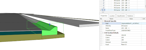
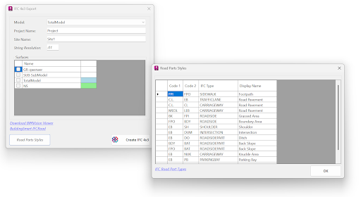
IFC 4.3 includes road-specific entities, enabling accurate representation of materials, layer thicknesses, and geometry. Users can automate the assignment of Road Part Types from the design cross section elements, ensuring compliance with IFC BIM requirements.
With the new wildcard option for assigning subgrade layers to codes in the Civil Site Design Template Editor, it is quick and easy to represent complex template conditions like benches or retaining walls in the IFC export.
The result? Smarter data exchange between design teams, asset owners, and contractors—ensuring models remain useful throughout the project lifecycle. With tools like BIM Vision or other IFC viewers, users can inspect the full structure of a model, view component properties, and verify that all key elements are present before construction.

The latest releases of Civil Site Design V26.10 and Stringer Topo V26.10 are here! These updates focus on addressing customer-reported issues, improving pack mode performance, and introducing new features and efficiency enhancements for working with COGO points and Survey Strings. Civil Site Design V26.10 is available on the following platforms: Civil 3D 2021 to Civil […]

Our streamlined design process shaves hours and days off your Civil 3D projects, including the creation of a Civil 3D Corridor complete with multiple regions, target mapping, and assemblies, at the click of a button. We always aimed to make the corridor like you would, reusing and consolidating similar assemblies wherever possible. So, for the […]

