Stringer Topo V24.20 has been released to support the BricsCAD V24 (as well as current releases of Autodesk software), including a number of new and improved features.
You spoke, we listened. You asked for functionality to make it easier to edit the essentials for points: point number, easting, northing, elevation and description.
We’ve created a new command: Quick Point Editor.
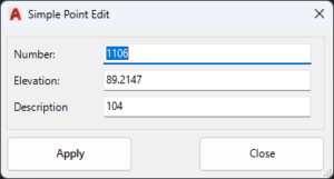
Run the command, pick a point, edit the essentials and apply the changes. Simple!
As well, we’ve made the Point List command editable.
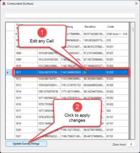
We probably should rename it Point List Editor. You can change any cell in here, then click Update Survey Strings to apply in your survey.
Otherwise, we’ve made changes in response to customer feedback, including:
- Improving the point transformation tool with a picker for setting controlled easting and northing locations
- Improving messaging for the Delete Segment command from the menu
- Adding an option in Stringer Settings to set the 3D linework settings to match the 2D
As per every update, we’ve also implemented fixes to address customer reported issues. Check out the read me page for further information.
Stringer Topo V24.20 is available on AutoCAD 2018-2024, Civil 3D 2018-2024 and BricsCAD V21-V24.
You will have access to the update if you have a current annual subscription or a active maintenance plan on your perpetual license. If you do not currently have an active maintenance plan, please email us at sales@civilsurveysolutions.com.au to arrange an upgrade to your account.

The latest releases of Civil Site Design V26.10 and Stringer Topo V26.10 are here! These updates focus on addressing customer-reported issues, improving pack mode performance, and introducing new features and efficiency enhancements for working with COGO points and Survey Strings. Civil Site Design V26.10 is available on the following platforms: Civil 3D 2021 to Civil […]

Our streamlined design process shaves hours and days off your Civil 3D projects, including the creation of a Civil 3D Corridor complete with multiple regions, target mapping, and assemblies, at the click of a button. We always aimed to make the corridor like you would, reusing and consolidating similar assemblies wherever possible. So, for the […]

