The latest releases of Civil Site Design V26.10 and Stringer Topo V26.10 are here! These updates focus on addressing customer-reported issues, improving pack mode performance, and introducing new features and efficiency enhancements for working with COGO points and Survey Strings.
Civil Site Design V26.10 is available on the following platforms:
- Civil 3D 2021 to Civil 3D 2026
- AutoCAD 2021 to AutoCAD 2026
- BricsCAD V22 to BricsCAD V25
- Civil Site Design Plus
Core fixes have been added to all platforms. New features have been added to Civil 3D and AutoCAD 2025 and 2026 versions, as well as Civil Site Design. These new features will also be included in the upcoming BricsCAD V26.
Let’s have a look at the new features and improvements we’ve added to V26.10.
Survey Defaults
The latest update to Civil Site Design and Stringer Topo introduces two new default settings under Survey Defaults, designed to save time and ensure consistency across your projects.
- Default Coordinate System: You can now set a default coordinate system. This system will be automatically applied whenever you use the Satellite Surface or Satellite Image commands, eliminating the need to select it manually for the Image from Satellite and Surface from Satellite commands.
- Default Point Group: A new default Point Group can be set. This group will be automatically presented as the default selection in all forms and commands where a point group is required, streamlining your workflow and reducing repetitive selections.
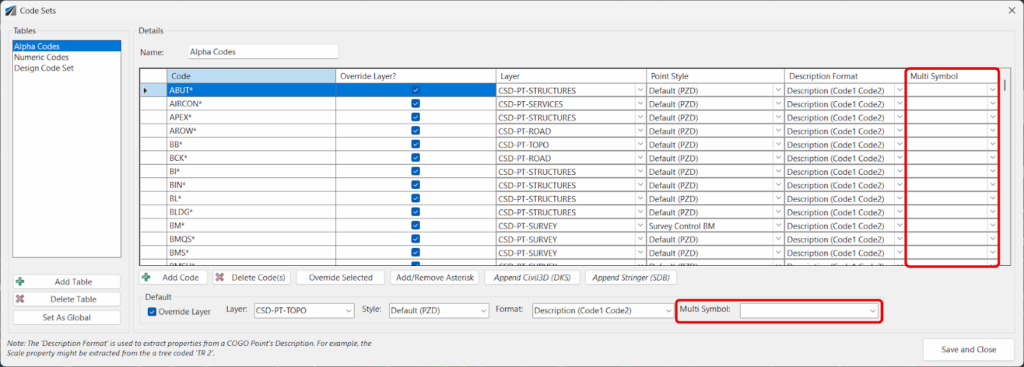
Multi-Symbol Functionality Enhanced
The Multi-Symbol feature has been significantly improved, providing greater flexibility and automation when working with COGO points.
Previously, multi-symbols were applied only via a point group, but now we’ve improved accessibility by integrating it directly into the Point Code Set. This means you can now create multi-symbols on your COGO points based on their Point Codes, as well as via Point Groups. This enhancement saves considerable time and ensures that your symbol representations are consistent and tied directly to your survey data.
Once created, making edits to your COGO points in the drawing will automatically reposition the scaled blocks to match.
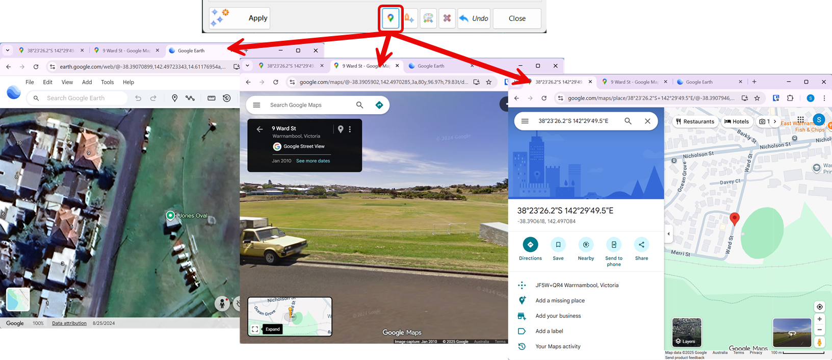
Launch Google
A new Launch Google button has been added to the Point Groups and Edit Point commands, providing a quick way to visualize your project data.
By selecting a COGO point and clicking this button, the software will automatically open Google Earth, Google Maps, and Google Street View to that specific point’s location. This allows for instant, real-world context and a better understanding of the site’s surroundings directly from your design environment.
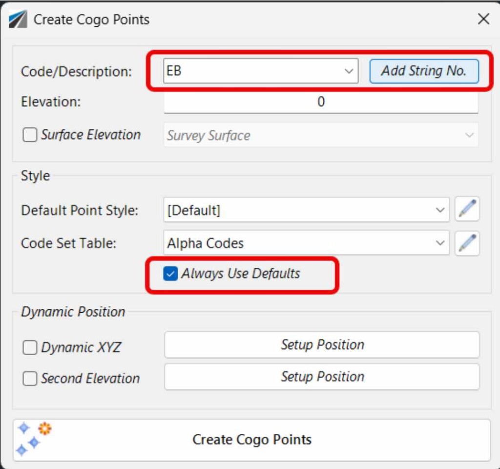
Create Points
The Create Points form has been enhanced with several new features designed to streamline the point creation process.
- Code Picklist: A new option allows users to select Codes directly from a picklist, which is populated from the selected Code Set Table. This improves accuracy and speed, but still allows you to overtype for any code and string number combination as needed.
- Append next available String Number: Automatically append the next available string number to the selected code, making it quick and easy to begin a new string of points.
‘Always Use Defaults’ Toggle: This new toggle gives you control over the form style defaults. You can either populate from your inputs in the Survey Defaults form or remember your last used settings.
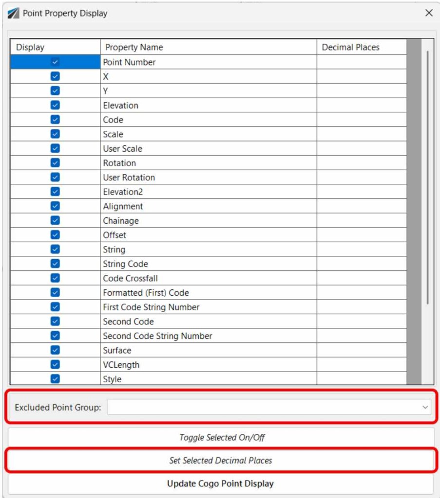
Point Property Display
The Point Property Display form has been updated to give users more control over the appearance and editability of their points.
- Decimal Place Override: You can now override the number of decimal places used to display numeric point properties, which helps to maintain a clean and consistent drawing presentation.
- Point Group Exclusion: This feature allows you to exclude all points within a selected Point Group from being edited. This is useful for protecting critical survey points or design elements from accidental changes.
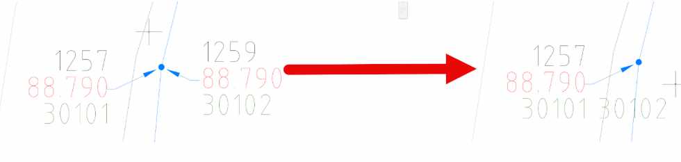
Combine Points
A new command, Options > Combine Duplicate Points, has been added to the Point Groups functionality. This feature is designed to clean up your data by identifying and merging duplicate points—that is, points that share the same x, y, and z coordinates within a user-defined tolerance.
When the command is run, it combines the duplicate points by appending the Code of the second point to the Code of the first point, effectively creating a “multi-coded” point. The second point is then removed from the drawing, reducing clutter and ensuring data integrity. This process helps to streamline your survey data and eliminate redundant information.
Licensing Improvements
The latest updates make it easier for users to get started and for administrators to manage licenses.
Evaluation Tab
- Educational License Request: A new button has been added that allows students to directly request a free educational license. This simplifies the process for students and educators who need access to the software for non-commercial, learning purposes.
- “No Company” Checkbox: Users can now request a software evaluation as an individual rather than as a company. This is a simple but important addition, making the trial process more accessible to freelance designers, consultants, or anyone who wants to try the software without a formal business affiliation.
Settings Tab
- ‘Enterprise Mode’ Option: This new option in User Settings allows administrators to hide user account and license key access from individual users. When enabled, users can run the software but cannot see the license details. This is particularly useful for larger organizations where a central IT department or administrator manages all software licenses, preventing accidental changes or unauthorized sharing of license keys.

Our streamlined design process shaves hours and days off your Civil 3D projects, including the creation of a Civil 3D Corridor complete with multiple regions, target mapping, and assemblies, at the click of a button. We always aimed to make the corridor like you would, reusing and consolidating similar assemblies wherever possible. So, for the […]

Field attributes provide Surveyors with the ability to include additional data in their Survey pickup of points. With Stringer Topo V26 users can now include additional data (attribute data) with their COGO points and survey strings for review, editing and output from their drawing. There are a number of ways to add attributes to your […]

